


Uncharted Island Discovery 2026: Antarctic Expedition Reveals Hidden Landmass Set for Nautical Charts
A scientific expedition in Antarctica has identified a previously uncharted island in the northwestern Weddell Sea, a discovery that will now lead to updates in international nautical charts. The finding was made by researchers and crew aboard the German icebreaker Polarstern during an expedition led by the Alfred Wegener Institute (AWI), one of the world’s leading polar research organizations.
The newly surveyed island is small but significant. According to the expedition team, it measures about 130 meters in length, around 50 meters in width, and rises roughly 16 meters above the water. Although the island had not been properly recorded as a coastline in nautical charts or other datasets, the area had already been marked as a navigation hazard, suggesting that mariners or previous observers may have known something unusual existed there without fully documenting it.
How the Antarctic island was discovered
The discovery happened during an AWI expedition that has been operating in the northwestern Weddell Sea since February 8, 2026. The mission’s main focus was not island hunting. Instead, the 93-member international expedition was studying the outflow of ice and water from the Larsen Ice Shelf and examining major changes in Antarctic sea ice in a region that matters for global ocean circulation.
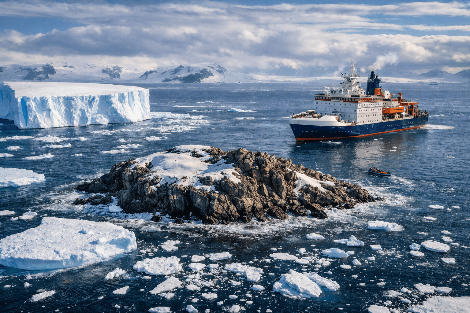
During rough weather, the Polarstern had to interrupt its research work and seek shelter in the lee of Joinville Island. It was during this maneuver that scientists and crew noticed what first looked like a dirty iceberg. Simon Dreutter of AWI’s bathymetry section later explained that the chart for the route showed an area with “unexplored dangers to navigation,” but it was unclear what exactly the warning referred to or where the original information had come from.
Curious about the chart warning, Dreutter checked coastline data available in the ship’s bathymetry lab. Looking out from the bridge, the team then spotted an object that resembled a grimy iceberg. As the ship moved closer, it became increasingly clear that the formation was rock rather than floating ice. That was the moment the expedition realized it had found an island that had not yet been systematically surveyed or properly recorded on nautical charts.
How the island was surveyed
After identifying the object as land, the Polarstern approached it carefully. The ship stayed in waters with at least 50 meters under the keel and came within about 150 meters of the island. From there, the crew circumnavigated the feature and used the vessel’s multibeam echo sounder to map the surrounding seabed. A drone was also deployed, and the imagery was later analyzed photogrammetrically to produce an elevation model and a georeferenced aerial image that allowed the coastline to be measured accurately.
This was the first time the island had been systematically documented. The final survey found that the landmass is slightly longer than the Polarstern itself, which is 118 meters long, and is roughly twice as wide as the ship. That careful surveying matters because even a relatively small rocky island can pose a real navigational hazard in polar waters, especially in areas where visibility is poor and the sea is filled with drifting ice.
Why the island was missed before
One of the most interesting parts of the discovery is not just that the island exists, but why it remained uncharted for so long. The AWI release notes that the island could barely be distinguished in analyzed satellite imagery because of its ice cover and the many icebergs drifting nearby. In other words, the feature visually blended into its environment. What looked like a dirty iceberg from the ship also appears to have looked iceberg-like from above.
The researchers also found that the position indicated by the nautical chart was about one nautical mile away from the island’s actual position. That means the hazard had been broadly noted, but not accurately defined. The island was effectively hiding in plain sight: hinted at on charts, not properly mapped in data sets, and difficult to distinguish in satellite images.
This is an important correction to some exaggerated retellings of the story. The team did not claim that the island suddenly emerged from the sea, nor did they say they had discovered a giant new landmass. What they actually reported was the systematic survey and documentation of a small island that had not yet been recorded correctly on nautical charts.
Read more on Mounjaro Leads India’s Obesity Drug Sales
What happens next
The island does not yet have an official international name. AWI says the next step is to go through the formal naming process. Dr. Boris Dorschel-Herr, head of AWI bathymetry and also part of the expedition, has prior experience with this kind of work. AWI noted that in 2014 he and his team helped ensure that two underwater mountains were added to nautical charts in the South Atlantic and the Weddell Sea.
Only after the naming process is complete will the team publish the island’s exact position. AWI also says the information will then be added to international nautical charts and other major geographic datasets. This matters not only for mariners but also for bathymetric mapping projects such as the International Bathymetric Chart of the Southern Ocean, or IBCSO, which can miss isolated features when observational coverage is thin and interpolation fills in the gaps.
Why this discovery matters
At first glance, a 130-meter-long rocky island may sound like a minor curiosity. In practice, it matters for several reasons. First, it improves navigational safety in Antarctic waters. Even small unmapped features can be dangerous for research vessels and other ships operating in remote polar regions. Accurate charts are not optional in such environments; they are essential.
Second, the discovery is a reminder that even in the age of satellites and digital cartography, some of Earth’s most remote regions still contain mapping gaps. Antarctica remains one of the least accessible parts of the world, and the combination of harsh weather, sea ice, sparse measurements, and visual confusion caused by ice cover means that errors and omissions can persist longer than many people assume.
Third, the island discovery came in the context of broader scientific work on Antarctic sea ice and oceanography. The same expedition has been studying changes in the Weddell Sea that could have larger implications for climate and global ocean currents. AWI researchers reported that summer sea ice extent in the northwestern Weddell Sea has declined sharply since 2017, likely linked to warmer surface water. They also described strong regional differences in ice thickness and surprisingly intense surface melting in some areas.
What the expedition found beyond the island
The island itself was only one part of the mission. AWI says its bathymetry team worked closely with physical oceanographers and other groups on board. Together, they tracked different water masses from the deep sea onto the continental shelf and studied seafloor colonization. The researchers also reported new insights into the decline of Antarctic deep water compared with long-term observations collected through AWI’s Hybrid Antarctic Float Observing System, known as HAFOS, since 2002.
The expedition further narrowed down outflow paths of cold water from the Larsen Ice Shelf. According to AWI, these water masses significantly influence global ocean currents and sea ice melting, especially over the continental shelf. In addition, researchers observed strong surface melting of sea ice, including snow-free and bluish or grayish surfaces, along with freshwater lenses in and under the ice that can affect biological colonization and heat exchange between ocean and sea ice.
These details are important because they place the island discovery within a larger scientific picture. This was not an isolated curiosity trip. It was a major polar research mission, and the island became one of its most unexpected findings.
A discovery that still leaves questions
Some questions remain unanswered. AWI says it is still unclear why the island appeared on nautical charts only as a danger zone and why its mapped position was offset from the actual one. It is also not yet officially named, and its exact coordinates have not been publicly released. Until the formal process is complete, the discovery remains a rare case of a modern mapping correction still in progress.
What is clear, however, is that the island is real, it has now been surveyed properly, and it will soon be included in international nautical records. In a world that often feels fully mapped and fully known, that is a striking reminder that scientific fieldwork still has the power to reveal something genuinely unexpected.
Conclusion
The discovery of a previously uncharted island in the Antarctic Weddell Sea is a rare and credible modern exploration story. Verified by the Alfred Wegener Institute and reported via Phys.org, the finding was made by researchers aboard the Polarstern after they investigated a charted danger zone during bad weather. Their survey showed that the island is about 130 meters long, 50 meters wide, and rises roughly 16 meters above the water. It had not been properly recorded on nautical charts, partly because its ice cover made it difficult to distinguish from surrounding icebergs in satellite images.
The island will now go through a formal naming process before its exact position is released and added to international nautical charts and datasets. Beyond the headline, the discovery also underlines the continuing importance of polar field research, hydrographic surveying, and Antarctic climate science. Even now, in 2026, remote parts of Earth can still surprise us.